Introduction
The Water Resources Report was developed and is maintained by Hodge.WaterResources, LLC. On a daily basis, the Report accesses the Twitter feeds of state organizations that have a role in managing water resources. The Report searches each Twitter feed for mentions of water bodies and maps each one it finds. You can use the Report to see what’s happening near you and throughout the country.
Objective
Social media can be a source of immense amounts of data on a range of topics. The major challenge in harnessing that data to support an initiative is to make that data intelligible. The goal of the Water Resources Report is just that. The Report distills useful information from social media about water resources across the United States. The Report can be a tool for scientists, engineers, advocates, and all stakeholders to learn about, discuss, and keep current with activity on a specific water body.
Application Structure
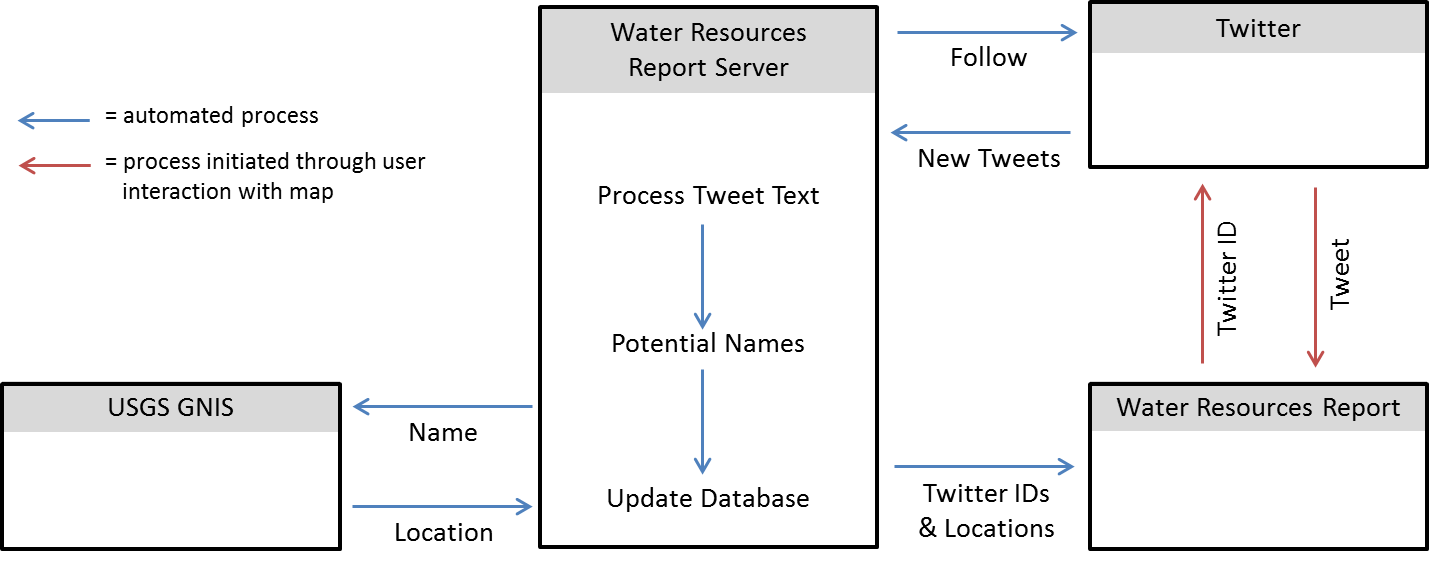
The Report is a web application that interacts with the United States Geological Survey (USGS) Geographic Names Information System (GNIS) and Twitter. The Report itself is presented as a map of locations with the ability to review tweets that are relevant to a given location. The following figure provides a work-flow schematic for the Report.

The server-side components of the report are built with node.js. The Report uses the Twitter Application Program Interface (API) to get the most recent tweets from a given Twitter user (typically a state agency/authority). The Report then reads each tweet searching for keywords (e.g., "lake", "stream", "bay", etc.). If the Report finds a keyword, it then builds a set of potential water body names based on the content of the tweet. The Report then sends an API request to the USGS GNIS to see if there is a record that matches each potential name. If the USGS GNIS confirms that a record exists for a potential name, the Report makes an educated guess on which potential name/record is the correct one and initiates a database update.
The Report uses a PostgreSQL database to store tweet/location pairs. The Report only stores tweet identification numbers in the database and pairs them with locations; it does not store any metadata about who made the tweet or the content of the tweet. The locations are used on the website at WaterResourcesReport.com as a part of an Angular web app. The app includes a Leaflet.js and D3.js map of the United States that plots out each location that is part of the Report. Each location is color-coded based on how recent the tweet is (red: within the last two days, blue: more than ten days old) and size-coded by the number of tweets at the location (larger: more tweets, smaller: fewer tweets). Users can click on a location to see the tweets about that location or look at recent tweets and click a map marker to zoom to the relevant location.
Tweet of the Day
Hodge.WaterResources, LLC reviews recent tweets daily and picks their favorite to be showcased on the homepage of the Report.
Future Enhancements
The Report is always being improved, whether through additional content, adjustments to existing data, or enhancements to the app itself. Future enhancements to the Report will likely include:
- the capability for super-users to make corrections to locations
- A spatial query allowing the user to see all the tweets within a given window of the map
Report Follows
The Report is always looking for new Twitter accounts to follow that will provide insights about water resources. Currently the Report follows these accounts.
| Private Name | Handle |
|---|---|
| ---- | ---- |